
Revolutionizing Low-Income Housing Tax Credit Site Selection for Real Estate Developers
In the ever-evolving landscape of real estate development, securing Low-Income Housing Tax Credits (LIHTC) requires a strategic and agile approach. Location intelligence and data analysis are increasingly empowering developers to streamline and scale the identification of LIHTC qualifying areas. However, traditional site selection solutions can be complex and labor-intensive, requiring real estate developers to source and clean a wide variety of data before even starting an analysis.

Datastory updates MapDash each year with a layer of LIHTC qualifying census tracts across the US.
MapDash™ is reshaping the real estate industry's approach to site selection by providing turnkey location intelligence capabilities without the heavy lifting. With MapDash, real estate developers can easily analyze communities for LIHTC site suitability by simply toggling on and off different pre-configured datasets, including demographics, environmental conditions, local business information, and more. These datasets are not only ready-to-go in MapDash’s robust data library, but also maintained to stay up-to-date with our rapidly changing world. What’s more, MapDashs’ easy-to-use geospatial analytics tools enable real estate developers to perform common workflows like drivetime analysis, proximity studies, and site scoring with just a few clicks. It’s never been easier for developers to perform data-driven LIHTC site selection.
Let's delve into how MapDash is changing the game for real estate developers, with insights from Houston Brown, Vice President at Investors Management Company.
Understanding the LIHTC challenge
Low-Income Housing Tax Credits are a critical resource for developers committed to creating affordable housing. According to the US Department of Housing and Urban Development, more than 3.5 million affordable housing units have been created since the passage of the Tax Reform Act of 1986. Each year, the federal government works with states and local communities to allocate around $9B in tax credits to real estate developers who build qualifying housing units.
Qualifying units are determined by whether or not specific criteria meet the Qualified Allocation Plan (QAP). In general, properties must meet one of these three criteria established by the QAP for a period of 15 years after development:[1] [2]
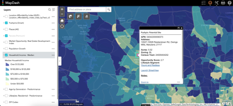
MapDash is pre-configured with granular socioeconomic data, making it easy to visualize and identify trends that indicate ideal sites for LIHTC properties.
At least 20% of the units must be rented to individuals with an income that’s no more than 50% of the local median income, adjusted for family size.
At least 40% of the units must be rented to tenants earning no more than 60% of the local median income.
At least 40% of the units must be leased to tenants whose income does not exceed 60% of the local median, with no units rented to tenants earning more than 80% of the local median.
Given the competitive nature of the real estate industry and the specific criteria that must be met in order to qualify for LIHTC, developers are increasingly turning to location intelligence solutions to achieve an edge.
MapDash: a game-changer in site selection
As a web-based location intelligence platform complete with pre-configured data, analysis tools, and infographic templates, MapDash is revolutionizing how real estate professionals research and select sites for LIHTC developments. MapDash includes highly detailed geospatial datasets that show the average income of different neighborhoods and communities across the country, making it simple for developers to identify which areas meet QAP criteria at scale. Real estate developers no longer need to source and analyze income data for different areas from disparate sources; instead local data is available for the entire US with just the click of a button.
This data is easily layered onto MapDash’s interactive map interface to display patterns and trends. Additional site suitability data is also pre-configured to allow developers to take their analysis one step further. For example, developers can layer wetland data onto an income map to avoid applying for a LIHTC project in a protected area. Once these insights are uncovered and a site is selected, MapDash’s infographic and report generation capabilities help real estate developers communicate their findings with other stakeholders, and provide additional context for their LIHTC application.
"As a real estate developer, MapDash has revolutionized our approach to discovering new development prospects. In the competitive world of real estate, speed is crucial, and MapDash has proven to be an invaluable tool in helping us identify opportunities faster than our peers. Gone are the days of manual, site-by-site evaluations; with MapDash, we can effortlessly explore the entire state, swiftly pinpointing high-opportunity areas, and honing in on the most promising sites. This has not only enhanced our efficiency but has given us a significant edge in identifying and securing prime locations for our projects." - Houston Brown, Vice President at Investors Management Company[1] [2]
Key features of MapDash for LIHTC real estate development
Location intelligence is an invaluable tool for all real estate development, but at Datastory we tend to see MapDash used for the following LIHTC site selection and analysis workflows:
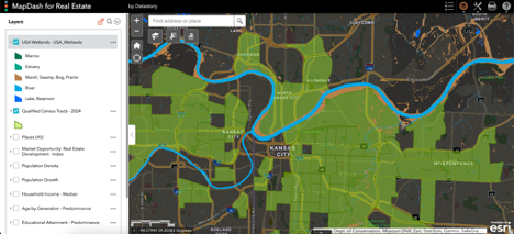
MapDash makes it easy to find layer multiple site suitability criteria data together for more informed LIHTC development decisions.
Identifying sites that meet QAP criteria
MapDash’s rich datasets and easy visualization and analysis tools enable developers to quickly identify sites that meet QAP criteria, beating out the competition.Adapting to regulatory changes
With real estate regulations shifting annually, MapDash provides the data needed to keep up with each round of the QAP draft, offering a competitive edge in a landscape where opportunities evolve constantly.Analyzing data accurately & efficiently
MapDash empowers developers to perform complex data analysis with just a few clicks, allowing them to confidently find locations that score the highest on a LIHTC site suitability scale.Synthesizing multiple datasets for deeper insights
The curated and robust data library pre-configured within MapDash includes crucial elements for LIHTC analysis, such as amenities, target areas, and socioeconomics, providing developers with a comprehensive view of local communities across the country for informed decision-making at scale.
Scalable LIHTC site selection with MapDash
Location intelligence is transforming the way LIHTC projects are approached by real estate professionals. With the affordable turnkey location intelligence capabilities provided by MapDash, developers can now navigate the complexities of site selection efficiently and confidently, ensuring that they not only secure the credits they need but also provide future tenants with optimal access to jobs, amenities, and resources.
MapDash elevates location intelligence and maximizes the competitive advantage of real estate developers in the LIHTC multifamily industry. To embark on a journey of streamlined site selection and data-driven success, get in touch with the Datastory team. Our LIHTC experts will help learn more about MapDash, explore our QAP data packages, and redefine the future of low-income housing development.