
The Power of Maps Made Easy: How Datastory Puts Location Intelligence in Everyone's Hands
Whether you realize it or not, location intelligence technology is everywhere in today’s business world. Understanding “where” is proving to be the key to the “why”, “when”, and “how” of business decisions. For example, organizations are looking to create a digital twin of their assets to drive strategic planning, perform trade area analysis to match products and services to locations, and segment customer data using lifestyle/demographics to better segment marketing and sales tactics. These are just a few common examples among a growing list of powerful and differentiating use cases for location intelligence in business. At the same, consumers are increasingly reliant on mapping technology as they search for the nearest store, plan their next vacation, and “geotag” photos on social media.

There’s no denying location intelligence is a critical part of many daily activities in our professional and personal lives. However, the technical and communication skills needed to fully harness the potential of geographic information have historically been reserved for those with a specialized technical background, making it difficult for all organizations to leverage rich location insights.
For example, imagine you need to make location-data-driven decisions for your business but don't have a background in geospatial analysis. Chances are you haven’t heard of a “polygon”, “raster”, or “shapefile” and have no idea what an “Esri” is. This is where Datastory comes in. We are industry-recognized experts in demystifying the complexities of location intelligence, and our solutions serve as an “on-ramp” to organizations that want to get started using it. We are proud to be an award-winning business partner with Esri, the world-leading provider of GIS technology and data, yet also a company that most people haven’t heard of (but should).
In celebration of GIS Day, we want to showcase how our intuitive platform, MapDash™, is making location intelligence accessible for all users, not just highly-trained GIS experts.
Geo-enabling organizations with location intelligence
What does “GIS” even mean? The acronym stands for geographic information systems, and can be thought of as a super-smart map on steroids. GIS lets you layer a multitude of different location-based information onto maps to uncover insights and trends, and even analyze dynamically changing datasets to stay on top of a constantly evolving world. With GIS, you can better understand anything that happens on our planet, analyze how it interconnects, and determine what that all means for your specific organization.

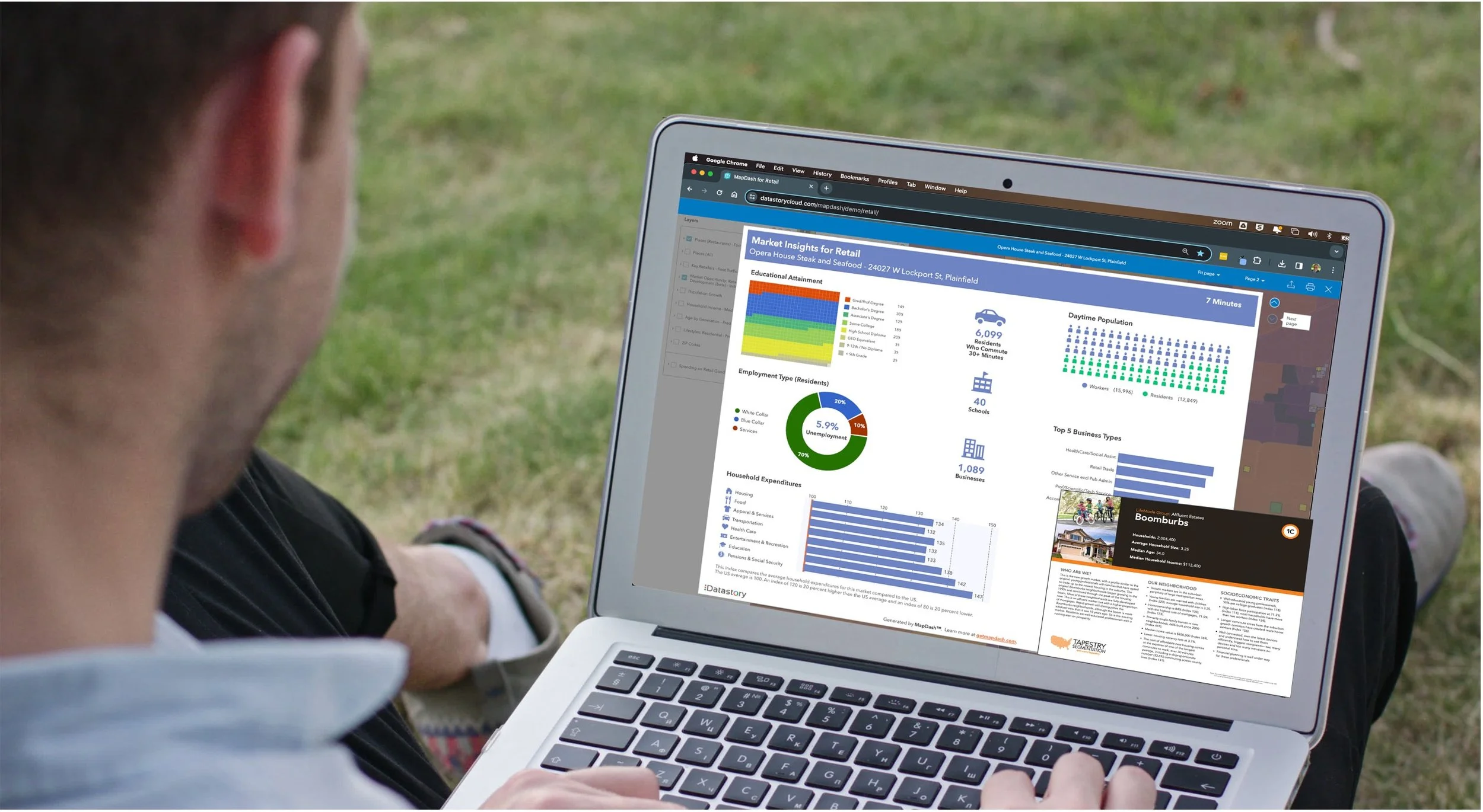
GIS accomplishes this through a mix of location-based data and spatial analysis tools. Sound overwhelming? Well, it can be. With MapDash’s pre-configured collection of best-in-class data, and easy-to-use and tools, anyone can harness the power of maps and spatial data to gain valuable insights. Plus, MapDash enables you to analyze data through the lens you need, so you’re not bombarded with noise from irrelevant information.
Our easy-to-use visual interface lets you create customized maps in minutes even if you’re not a “technical person”. Whether you want to map customer locations, analyze sales territories, or optimize sales opportunities, our easy-to-use platform helps you visualize your data on a map with a few clicks. There’s no need to source and clean complex geospatial datasets - simply turn on the data you need and fast forward to accomplishing your end goal.
Behind our simple interface, we leverage enterprise-grade GIS technology tuned to support everyday business needs. From heat maps that reveal opportunities to localized trade area statistics and customer lifestyle segmentations, you have all the spatial analysis tools to make smarter decisions.
Datastory has a long track record of successfully helping industry professionals elevate their location intelligence with insights from MapDash. Some examples of non-GIS users of MapDash include:
Real estate developers
Retail category managers
Nonprofit program coordinators
Education enrollment directors
Economic development leaders
With Datastory's intuitive approach to delivering location intelligence, non-GIS users can spatially understand their data and tell impactful, visual stories. As an example, MapDash’s site selection tools empower real estate developers to map out information that provides the geographic advantage needed to outperform the competition. Similarly, MapDash’s pattern-matching and market opportunity analysis tools help retailers optimize their supply chains and meet sustainability goals. Users only need to focus on what they are trying to do - not the technical nuts and bolts of how to do it.
On this GIS Day, we celebrate opening the world of maps and spatial analysis to all users. We are proud to enhance the accessibility of location intelligence by working with a wide range of users across industries, regardless of their own background in GIS.
Don't let unfamiliar technical jargon prevent you from capitalizing on location intelligence. To see how Datastory can become your go-to location intelligence partner, sign up today for a demo of MapDash. Let us help you discover the power of maps made easy, for everyone - not just the GIS geeks!